I am hiking the Te Araroa, a long distance hiking trail which spans the length of Aotearoa (New Zealand).
This blog post covers the following sections of the trail on the south island: Rakaia river to Rangitata river; Rangitata river crossing; Two Thumb Track. (We did not attempt to cross the Rakaia river on foot, and we met no other hikers who did this). You can also read part 1, part 2 & part 3.
Rakaia river to Rangitata river
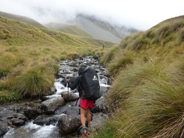
Rivers rivers rivers. I can’t remember when we weren’t walking through rivers, streams or creeks, and today I’m sick and tired of it. When was the last time I had dry shoes? I can’t remember.
The terrain has changed. Gone are the mossy green fairytale forests. Everything is brown. We’re walking through one of the south island’s massive sheep stations (a ‘station’ is a farm). Spiky matagouri and speargrass plants pierce my skin and make me bleed. I fall into a matagouri bush. It’s like falling onto a bed of needles. My hands are covered in tiny splinters, embedded deep into my skin.


If we’re not walking through rivers and dodging spiky plants, we’re hiking through metre-high tussock (tussocks are massive clumps of grass). The tussock makes it impossible to see the ground, and both Chris and I stumble and fall into deep holes in the ground. I hate tussock.


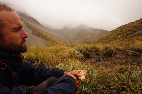
But then there is immense beauty. Lake Emily shimmers with the Alps behind her. Black swans float on the water.

Bad weather is coming in fast. We still have another 23km of this section to walk before we arrive at the bank of the Rangitata river. Arriving at a road, we need to decide whether to hitchhike the last 23km, enabling us to cross the Rangitata river before the bad weather hits.
“The Rangitata’s as low as can be,” a local person tells us. “But after that rain hits tonight it won’t be crossable, maybe for a couple of days.”
We’re torn. Should we hitchhike and ‘cheat’?
But when we see a Department of Conservation van drive past us with a HAZARDOUS CHEMICALS sign strapped to the trailer, hitchhiking becomes the best option. DOC is loading a helicopter with poisons which are then being sprayed onto the land that we’re about to walk through. There are no signs up to warn hikers that this is happening.
“DOC are spraying pesticides from the air to kill gorse and broom bushes,” one driver says to us when we ask him what’s going on. Another driver tells us that DOC is using the spray to kill the pine trees in the area.

“Don’t worry about the poison,” a local says to us. “Once it soaks into the ground it’s perfectly safe.”
Hmmm.
Rangitata river crossing
The Rangitata river is described as a ‘hazard zone’ by the Te Araroa Trust, meaning that the Trust feels that it’s now too dangerous to be a part of the trail. But most hikers are successfully crossing the river on foot.
As we walk through cow farms to get to the river, I’m amused that this valley was used in Lord of the Rings as the Kingdom of Rohan.


Crossing the Rangitata is relatively straight-forward and takes about one and a half hours. The Rangitata is not one massive river, but rather a series of smaller branches. We meet three other Te Araroa hikers and cross the faster-flowing branches as a group of five, linked together for safety.


The Rangitata river is *NOT* crossable without some kind of GPS or phone app telling you exactly where you are (unless you’re an absolute genius at map-reading). The route is not waymarked.
I feel a sense of achievement at having crossed the Rangitata. I had read about this river months before getting here, and it feels like a Te Araroa milestone to cross it.
The bad weather hits us one hour after we successfully cross the Rangitata river. Our MSR tent, less than one year old, starts leaking through the seams.
Two Thumb Track
This section begins with a walk up a beautiful gorge filled with beech trees, crossing the Bush Stream numerous times. The word ‘stream’ is not indicative of how strong the water is! Like many New Zealand rivers, the water is much stronger than it looks, and Chris and I link together to do the many crossings safely.


The trail continues up through tussock, wetland and more brown countryside. We arrive at Stone hut, wet and cold.
“Why the hell did they build this hut on an avalanche path?” I say to Chris, looking at the pile of rocks threatening to tumble down onto the hut.
We go inside the hut and find a sign warning us that Stone hut is, indeed, on an avalanche path. And then we find HOT WATER BOTTLES! We have a cosy evening alone in the hut, hot water bottles keeping us warm as the rain lashes down.


The following day we traipse through more freezing cold streams and walk through tussocks covered in icy cold droplets of water which saturate our clothes and shoes.
We make a foolish decision to walk over Stag Saddle, the highest point of the Te Araroa at 1900 metres, in the cloud and rain. As we cross the saddle, we’re caught out when the weather suddenly changes; the cloud thickens to fog and the icy wind bites at us. We can no longer see the waymarkers or the trail, and I use the GPS on my phone to help us to navigate our way down the mountain.


It takes what seems like forever to reach the next hut. With soaking wet feet from stream crossings and numb fingers, I’m on the brink of hyperthermia.
The next day marks the end of our Two Thumb track ordeal. I feel exhausted as we wade through more creeks. With dark circles under my eyes, I find it hard to stay positive as spiky matagouri bushes rip my skin.
Finally, as we approach glistening Lake Tekapo, the sun comes out and a bright blue sky appears. My fingers and toes thaw out and the Two Thumb track ordeal becomes a bad memory!


A brilliant read, and the photographs are incredible. We’re still training up our little children to hike at the mo but … one day 🙂
LikeLike
hi!
i just walked the Routeburn – one of NZ’s ‘Great Walks’ – and there were young children on that. i’ll write about it soon 🙂
LikeLiked by 1 person
I’ll really look forward to that! 🙂
LikeLike
Gorgeous landscape, so different from anything I have ever backpacked in before. I hope you are finding yourself warm and dry now!
LikeLike
Hey, I recently discovered your blog. I am so excited to read all from the beginning of. I hope you’re good now. Good luck!
LikeLike
Hey! I recently discovered you blog. I am so excited to read all from the beginnings of. I hope you’re well. Good luck!
LikeLiked by 1 person
Thank you! 🙂
LikeLike
Hi I just read all your posts and loved 5. Though I cant comment in it.
Youve helped answer my question. .. after reading about TeAroroa for awhile now I’m not convinced to thru hike it completely so have decided on Queen Charlotte to Tekapo next summer. Felt reassuring knowing u dont suggest the full trek.
Curious what guidebook did u use?? I bought the Geoff Chappell one but its huge and just glossy. Lacks info I want like places to resupply food or get mail drops (vegan treats are hard to source).
Any tips or links would be much appreciated.
Thank you
And I look forward to seeing where u go after you hopped off it.
LikeLike
hey!
i’m glad that the blog post was useful 🙂 🙂
we used the TA wiki to help us to decide whether to do maildrops and where to get our resupplies.
most other people sent mailboxes to pelorus bridge, st arnaud, boyle village and arthur’s pass. we didn’t do that and instead chose to hitchhike off the trail to get food. (this was because we didn’t know if my knee injury would get bad again and we might not reach the destinations of our packages!!)
if you want to feel like you’re doing a thru-hike then send the packages 🙂
As for a guidebook, we didn’t use one. we printed out the official trail notes from the Te Araroa website and we also printed out the official maps, which are also on the website. but you should only print the maps in colour and in A3 (we tried to save money by printing A4 and they weren’t useful!) The cheapest place to print maps in NZ is a shop called Warehouse Stationery, which is in all cities.
other TA hikers were using a different, better map. apparently people have put the download link on the TA Facebook page, so maybe you can search for it 🙂
The trail notes and the maps are not great. i normally hike with good guidebooks (such as the Topoguides in France), and i was quite disappointed by the lack of detail in the TA trail notes and maps. but it’s great that the TA Trust provides them for free 🙂
Most hikers from the US were reliant on their mobile phones and many didn’t use paper maps. most of them had a phone app called GutHook (and i think there is also another app for the TA). GutHook tells you where every wild camping spot and water source is, as well as your location.
We filtered our water most of the time (using a purifier bottle by Grayl) but many hikers drank straight from the rivers if there were no farms around.
one more piece of advice: there is a Poste Restante system in NZ, meaning you can send mail to a town’s post office and collect it in the future. BUT the post offices do not accept packages from courier companies. I didn’t know this and all of the mail that i directed to a post office was sent back to the sender (contact lenses, hiking poles, water filters etc). if you buy something online from a private company, it will usually be sent by courier and therefore not eligible for Poste Restante!
LikeLiked by 1 person
Oh my thanks for all that. I have noted it in my journal. THANK YOU!
LikeLike