The Madeira Ultra Trail is a short thru-hike that isn’t actually a thru-hike at all. At around 120km long (depending on your route!), the trail is actually an ultra marathon route. But more and more hikers are walking this stunning trail which crosses the island from west to east. The trail took me and my friend 5 and a bit days.
This trail is only tough because it is very, very steep! There’s around 8,000 metres of climbing in total, a lot of which involves steps. But the trail isn’t technical, so if you’re fit you should be able to easily complete it.
First of all I’ll talk about my experiences on the trail, and at the end I’ll tell you all the stuff I wish I’d known beforehand about logistics, such as where to get food and water, where to wild camp, and which GPX track I used to navigate (there’s no waymarkers to follow on this trail, so you’ll need to rely on your phone),
I hiked the trail in March 2022.

Day 1: Porto Moniz to forest above Ribeira de Janela (approx 8km)
“You do know that people DIE hiking here?” the woman working in the outdoor store in Funchal tells me as she looks me up and down. “You need to listen to me as a local. The trails here are very dangerous. Your shoes aren’t good enough.”
I point out to her that she is selling a whole shop of trail running shoes similar to mine.
“But it’s not about your shoes,” she replies. “You know, there are three hikers whose bodies have never been found.”
I tell her that I’m an experienced hiker, but as we leave her shop, I know that she thinks we are walking to our deaths.
I’m with my friend Tom and we’re in Madeira’s capital, Funchal. The start of the Ultra Trail is right over the other side of the island, in a town called Porto Moniz. There’s just one bus per day, and we’ve missed that, but we wanted to hitchhike anyway.
Hitchhiking proves to be really easy, and a mixture of locals and Portuguese tourists whisk us to the trailhead quicker than the bus would have done.


It’s gone 5pm when we start the trail. If you’re unfit, you will be unpleasantly shocked by the start of the Ultra Trail. Steep would be an understatement.
We climb roads then zig-zag down through farmers’ terraces, past the ghost town of Ribeira da Janela and then steeply up up up again. We finally reach forest and camp under giant eucalyptus trees. Their scent is my favourite in the world. Words can’t really describe the tropical, Jurassic Park feel of this island.


Day 2: to Estanquinhos (approx 24km + 3km extra as we get lost)
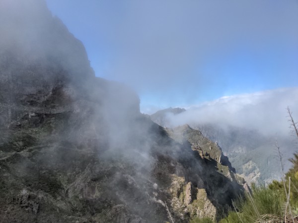
Today is steep. We reach Fanal, one of the most famous tourist spots on the island, famous for its thick fog and ancient laurissilva trees. Quite why tourists are excited about leaving behind the hot coast to come up into thick Scottish-like fog is beyond me. The laurel trees are stunning, though, covered in thick moss and with twisted trunks.
We begin the relentlessly steep descent through forest to the lovely little village of Chao da Ribeira. The village is set in a valley with epic mountains surrounding it, reminding me of Thailand.


We huff and puff up the steep Vereda da Terra Cha path, which climbs forever up through magical forest. Eventually we get above the tree line, and we’re surrounded by heather which grows as tall as small trees here. The sun stunningly sets as we continue to struggle exhaustedly up.
We continue in the dark, eager to get to Estanquinhos. I forget to check the GPX, and we end up on a tarmac road, a few miles from where we’re meant to be. I curse as the dark engulfs us and the icy wind howls as we stand on Madeira’s treeless equivalent to Dartmoor.
Words can’t express our joy at finally reaching our camp site – an official wild camping and picnic area – for the night. We briefly eat, set up our tents, and collapse inside them without much conversation. The night is freezing cold as we are engulfed in clouds.


Day 3: to 4km past Encumeada (approx 20km)
We pack down wet tents, soaked from the humidity, and begin walking at 9.30am. The much-needed sunshine warms us as we descend on easy Land Rover tracks below wind turbines.
Then we reach one of the highlights of the Ultra Trail, the Amazonias section, which follows a levada as it contours around the mountainside. We pass stunning waterfalls, tropical-looking plants, and eucalyptus forest, which at a gaze looks like rainforest. Old tunnels are carved out of the rock face.
We ascend up a ridgeline, the steps taking us up up up, with the clouds below us. Then we sprint and skid steeply down loose volcanic soil under giant eucalyptus trees.
I’m not sure what the name of the village is that we come to at the bottom, but of course we immediately climb up steps through forest, up past Rosario, continuing steeply til we get to the top at Encumeada.
We’ve been praying all day for the cafe to be open in the small tourist village. Luckily it is. We spend almost three hours lounging in the cafe with epic views down into the valley below, ordering all sorts of junk food. Piles of English retirees come in, having travelled here on tour buses.


It’s hard to drag ourselves out of the cafe, but we finally leave. I deliberately re-route us so that we miss out an excruciatingly steep climb next to a water pipe that I’ve read about on Jackson Groves’ blog. The re-route makes for easy hiking through eucalyptus.
The spot I’ve pre-picked on the map for camping turns out to be overgrown with brambles, and is too exposed to the strong winds, so we hike backwards a kilometre to an idyllic little grassy patch under silver birches, completely sheltered from the wind. I fall asleep listening to the fast flow of a waterfall just metres from us. Tomorrow we will traverse Madeira’s highest peaks, and the weather is supposed to be awful.


Day 4: to Pico Ruivo (approx 22km)
We’re expecting torrential weather today. But mother nature is kind to us, at least for the first half of the day, as we contour up around the mountainside on an annoyingly cobbled, slippery path. There’s lots of rockfall in this section.
We see the village and valley of Curral das Freiras (Nun’s Valley) far far below us as we begin the hour-long steep descent. Near the bottom, I navigate the wrong way, and we find ourselves GR20-style scrambling.
We finally reach houses, and then hike the extra mile uphill to the main village of Curral das Freiras. This extra mile of climbing can be avoided if you’re not being a purist, because you pass a little shop and cafe before the main village. But I’m being pretty anal about following the Ultra Trail to the millimetre, and so we lug our tired bodies up to Curral.
Once there, there’s a cheap cafe with stunning views of the Nun’s Valley below. Easily distracted by a cafe, we spend the next few hours there, knowing that bad weather is coming, but unable to drag ourselves away. We stock up at the little supermarket next door.


Just as it begins to rain, we leave Curral das Freiras, head back down the hill that we climbed a mile up, and begin the steep eucalyptus-covered ascent up to Madeira’s highest peak, Pico Ruivo. The rain hits us with monsoon force as we scramble over trees that have recently come down in a storm.
As we get above the treeline, we feel the full force of the bad weather, the rain lashing sideways against us in the howling, icy wind. It’s as cold as winter in the Scottish Highlands up here, and the climbing is relentless.
There’s some steep drop-offs in this section, which could be deadly in this weather if you’re not careful. Unlike the next section, which is full of tourists, this section doesn’t have so much wire fencing to aid you if you slip. I wouldn’t recommend anyone tries this section in torrential weather unless they’re a very confident hiker.
We finally reach Pico Ruivo, drenched to the bone. The rain has penetrated my waterproof layers, and the layers below. We search for one of the designated wild camping spots. But to our surprise, the little mountain refuge is open, and there’s a fire burning inside. We happily pay the man in the refuge 15 euros to stay inside for the night, and dry our gear off on the fire.


Day 5: to 1km past Poiso (21km)
We wake up at sunrise to rain and zero visibility as the clouds engulf us. So we have a slow breakfast, chat to some fellow hikers who have already hiked up from a car park, and leave the refuge at 10am.
The route between Pico Ruivo and Pico de Arieiro, Madeira’s third-highest peak, is the highlight of the Ultra Trail. It’s also packed with tourists, but for good reason. We wind along the mountainsides, pass through old tunnels, climb and descend steps which are precarious in the wet weather. At times the drop-offs are sheer and the paths are narrow, but there’s always a little wire fence to give hikers a false sense of security!
I’m blown away by this section, and I hike slowly, savouring it all, taking photos, and chatting away to all the people who have walked up here from their cars.
Pico de Arieiro has a military listening tower on it, a cafe, a souvenir shop and a big car park. I look at an exhibition about petrels, endangered birds that nest in the area, while Tom dries out his tent in the sunshine.


We descend down through scrubby broom trees. This is Tom’s last section of the trail because he needs to get back to the airport, and he finds limitless energy as he sprints his last couple of kilometres.
It’s with some sadness that I say goodbye to him as he reaches a tarmac road to hitchhike to Funchal, and I carry on the Ultra Trail alone.
I immediately start swearing: the trail has been blocked by a high fence. There’s a newly-bulldozed road inside the fence, and dead pines everywhere, reminding me of forestry land in Scotland. I have come to Madeira’s ugliest place. I try to detour, but decide that the best solution is to trespass. I climb the fence, walk the private track, and then duck under the fence again, following my GPX track carefully. I’m not the first person to do this: the fence is very bent from others ducking under it too.
I’m feeling pretty pessimistic, surrounded by dead pine trees, thick fog and cold wind. But then suddenly Madeira gives me what I am longing for: a forest of beautiful diversity. This is one of the only steep sections of the trail which doesn’t have human-made steps, which makes me happy.
Eventually I make it to the lovely little tourist spot of Ribeiro Frio, with its hiking trails, river and beautiful laurel forest. I make a mandatory stop at a little cafe, then continue onwards.
The trail winds up steeply through more laurissilva forest, before reaching a strange grassy plain with a derelict farmhouse. Then I pass up through a picnic spot of evergreen trees before reaching Poiso.
I can’t find the designated wild camping spot in Poiso, so I continue on about a kilometre and pitch up at one of the many flat grassy spots, 1500m high. The weather is dire. It’s foggy and the wind is howling. I snuggle up in my sleeping bag, thinking about my friends in my city back home, going out on their Saturday night. But I wouldn’t rather be anywhere else.


Day 6: to Machico (approx 25km)
It’s the last day of the trail, and it’s a long but easy one. I reach the stunning coast as the sun beats down on me, the trail hugging the cliff face.
After some hours, the trail leaves the coast and heads inland again, through a stunning leafy valley, and onto Machico. The last kilometres, through terraces of vegetables, seem to go on forever.
“Where did you come from? PORTO MONIZ??!” an old local woman exclaims in Portuguese. She’s the only person to congratulate me on finishing the hike.
I collapse on Machico beach for five minutes, before sticking my thumb out and hitchhiking back to Funchal, where I began this brief but great adventure.


Logistics!
Jackson Groves’ blog was what inspired me to hike this trail. He hiked it in four days, but I wouldn’t recommend that unless you are super fit and like very early mornings. I would say that it takes five days for the fit, and six days for the average person. It took me five and a bit days, but I did spend many hours in cafes, and I don’t start early in the mornings. I am, however, much faster than average at going up steep mountains.
Route planning and GPX
The Ultra Trail is an Ultra Marathon competition route which takes place once a year. Because of this, it isn’t permanently waymarked (as of 2022). The competition organisers also re-route the trail slightly from year to year, so there are many variants that a thru-hiker can walk, and there’s different variants of GPX routes that can be found on the internet. I met hikers who were walking slightly different routes to me. I was a purist, trying to stick to the most current Ultra Trail route, even though that meant I was hiking a number of excruciatingly steep sections which other hikers missed out.
I used this runner’s GPX track to navigate, which I downloaded from Wikiloc. It was the most current and accurate GPX that I could find (please note that if you use this GPX you will come to a blocked path that you’ll have to climb over (see my Day 5 notes above). You need to pay for Wikiloc, but I started a free trial, and then cancelled my subscription before any money came out of my account (sorry, Wikiloc!). Since hiking this trail, I have seen that at least one or two people have uploaded their more recent GPX routes onto Wikiloc.
Once I had downloaded the GPX track from Wikiloc, I uploaded it onto my OsmAnd maps app. I usually use OsmAnd for my hikes. I met someone else on trail who was using Mapy.cz.
Camping spots
There’s so many good wild camping spots on this trail, so you don’t need to worry! There’s also a number of designated free wild camping spots (see the overview here), a lot of which are on the trail and are definitely the best places to camp. The designated camping spots on the trail are in Porto Moniz (the only one you have to pay a small amount to stay at), Fanal, Estanquinhos, Pico Ruivo (there is also a mountain refuge up there), Ribeiro Frio, Chao de Feiteiras, and Poiso. They usually have picnic benches and a water tap, but no toilet. In theory, you need to get a permit to use them, but I never did, and I never saw anyone checking (although this might change in the summer months).
Water
Madeira is an island of levadas and waterfalls. I never had any problem finding water. I carried a water filter but I didn’t need it once, as I regularly went past taps or through villages. My OsmAnd map app also accurately showed me where water taps were.
Food supplies
For the first 63km of the trail from Porto Moniz, there are no shops, so you need to carry a few days’ worth of food. After that, there’s cafes in abundance. To my knowledge, these are the shops and cafes on the trail (please note that all my distances listed below are only estimates):
24km: Chao de Ribeira
– Cafe. Closed when we passed in the early evening
48km: Encumeada
– Cafe. A big menu of pizza, pasta, meat, plus a small shop selling cake and snacks like crisps. Closed Mondays, I believe, but check!
60km: Faja Escura (if you want to bypass the climb to Curral des Freiras)
– Bar. I didn’t go inside but it was open
– Small shop. Again, I didn’t go inside, but it was open
62km: Curral des Freiras
– Supermarkets
– Big cafe. Good selection, great views, cheap
72km: Pico Ruivo
– Mountain refuge (15 euros per night), sells hot and cold drinks, alcohol, cake and snacks like crisps
78km: Pico de Arieiro
– Big tourist area with large cafe and gift shops
87km: Ribeiro Frio
– Restaurant. I didn’t go inside but it was open
– Cafe/bar selling alcohol, soft drinks, ice cream, small snacks
92km: Poiso
Restaurant selling hot meals and drinks
100km: Portela
A couple of tourist restaurants. Open when I passed but I didn’t go inside
Follow me on Instagram

Madeira is a truly magical place. I absolutely loved it there. Would love to experience it hiking! Maybe one day I’ll go back! It’s a long way from Australia!
LikeLike
Well done Lisa..
In completing that tough hike in such bad weather conditions. Madeira looks stunning…at least when the weather is kind. Great blog too.
LikeLike
You’ve done it again! Brilliant hike and a brilliant blog!! Love you!!
LikeLike
Hi,
Congratulations for completing the full trail !! Looks like amazing.
I would like to do it in March 2023. And i would have a question.
Do you think it’s possible to sleep in a hamac all along the trail ? Is it guarantee to find 2 trees every night to tight a rope ?
thank you in advance
LikeLike
hi Zeko, yes, i think it’s possible with a hammock if you’ve got a tarp or a way to waterproof yourself. There’s a lot of trees!
LikeLike